article thumbnail

Spatial Intelligence: Why GIS Practitioners Should Embrace Machine Learning- How to Get Started.

Towards AI

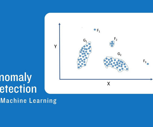
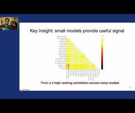
Created by the author with DALL E-3 Statistics, regression model, algorithm validation, Random Forest, K Nearest Neighbors and Naïve Bayes— what in God’s name do all these complicated concepts have to do with you as a simple GIS analyst? You just want to create and analyze simple maps not to learn algebra all over again.

article thumbnail

An Overview of Extreme Multilabel Classification (XML/XMLC)

Towards AI

The prediction is then done using a k-nearest neighbor method within the embedding space. The feature space reduction is performed by aggregating clusters of features of balanced size. This clustering is usually performed using hierarchical clustering.

professionals

Sign Up for our Newsletter

This site is protected by reCAPTCHA and the Google Privacy Policy and Terms of Service apply.

article thumbnail

Anomaly detection in machine learning: Finding outliers for optimization of business functions

IBM Journey to AI blog

This type of machine learning is useful in known outlier detection but is not capable of discovering unknown anomalies or predicting future issues. Unsupervised learning Unsupervised learning techniques do not require labeled data and can handle more complex data sets.

article thumbnail

Everything to know about Anomaly Detection in Machine Learning

Pickl AI

Density-Based Spatial Clustering of Applications with Noise (DBSCAN): DBSCAN is a density-based clustering algorithm. It identifies regions of high data point density as clusters and flags points with low densities as anomalies. Anomalies might lead to deviations from the normal patterns the model has learned.

article thumbnail

From Pixels to Places: Harnessing Geospatial Data with Machine Learning.

Towards AI

A sector that is currently being influenced by machine learning is the geospatial sector, through well-crafted algorithms that improve data analysis through mapping techniques such as image classification, object detection, spatial clustering, and predictive modeling, revolutionizing how we understand and interact with geographic information.

article thumbnail

Classification in ML: Lessons Learned From Building and Deploying a Large-Scale Model

The MLOps Blog

Traditional Machine Learning and Deep Learning methods are used to solve Multiclass Classification problems, but the model’s complexity increases as the number of classes increases. Particularly in Deep Learning, the network size increases as the number of classes increases. Creating the index.

ML 52
article thumbnail

Fundamentals of Recommendation Systems

PyImageSearch

K-Nearest Neighbor K-nearest neighbor (KNN) ( Figure 8 ) is an algorithm that can be used to find the closest points for a data point based on a distance measure (e.g., Figure 8: K-nearest neighbor algorithm (source: Towards Data Science ). Several clustering algorithms (e.g.,