Remove tag geology
article thumbnail

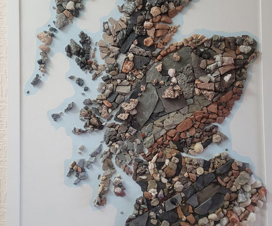
Rock map of Scotland

FlowingData

He collected rocks during amateur geology trips over 30 years. Tags: geology , Harry Young , physical , Scotland Harry Jefferies shared his grandfather’s 30-year project : My grandpa who is 85 started making this rock map of Scotland in 1992. He says it had to be geologically correct and also aesthetically pleasing.

79
article thumbnail

Mapping the sea floor

FlowingData

Tags: Jon Keegan , nature , ocean , USGS. Jon Keegan on how USGS researchers collected data for 125 square miles of sea floor : In 2004 and 2005, two research vessels, Ocean Explorer and Connecticut set off into the waters off Cape Ann, Massachusetts on a U.S. Geological Survey mission to map a section of the bottom of the sea.

104
104
professionals

Sign Up for our Newsletter

This site is protected by reCAPTCHA and the Google Privacy Policy and Terms of Service apply.

article thumbnail

Where America is expanding in developed areas

FlowingData

Tags: development , housing , USGS , Washington Post. My favorite part is the interactive map, which lets you see development in your area. The purple indicating newly developed areas against the grayscale provides a quick reference. The maps are based on data from the United States Geological Survey, which you can grab here.

120
120
article thumbnail

Mapping the cool spots in hot cities

FlowingData

Tags: Bloomberg , climate , cooling , heat. These snapshots of heat differences offer clear evidence of cooling strategies that can counteract what researchers term the “urban heat island effect,” in which city temperatures get that extra boost. Bodies of water, greenery, and reflective surfaces.

83
article thumbnail

Map shows you where a raindrop ends up

FlowingData

Tags: rain , Sam Learner , water. River Runner is a fun interactive map by Sam Learner. Click anywhere in the contiguous United States to drop some rain and, based on data from the U.S. Geological Survey , the map shows you where the rain ends up and the path it takes to get there. via Waxy ].

126
126
article thumbnail

Prepare training and validation dataset for facies classification using Snowflake integration and train using Amazon SageMaker Canvas

AWS Machine Learning Blog

In the Tags section, add a tag with the key SageMaker and value true. This post is co-written with Thatcher Thornberry from bpx energy. Facies classification is the process of segmenting lithologic formations from geologic data at the wellbore location. Choose Next.

AWS 74