Remove tag Regions
article thumbnail

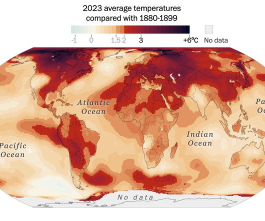
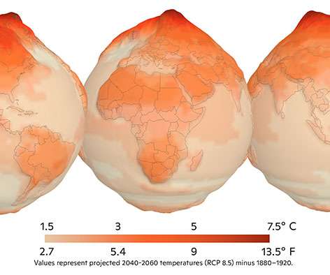
Where it warmed the most in the world

FlowingData

The Post has mapped the regions that saw the largest temperature anomalies in 2023 — places that have warmed so fast that the climate is already testing the limits of human infrastructure and the ability of the natural world to cope. Tags: climate change , global warming , Washington Post

134
134
article thumbnail

Mapping Israel and Gaza attacks

FlowingData

The New York Times is mapping rocket strikes, attacks, and ongoing conflict in the region. Tags: Gaza , missile , New York Times

91
professionals

Sign Up for our Newsletter

This site is protected by reCAPTCHA and the Google Privacy Policy and Terms of Service apply.

article thumbnail

Cost of a Big Mac at every McDonald’s in the United States

FlowingData

Based on Regional Price Parity , Montana tends to cost less compared to the national average, and Arizona is right in the middle. Tags: Big Mac , cost , McDonald's But what’s going on in Montana and Arizona?

122
122
article thumbnail

Cultural Midwest, not technically

FlowingData

Census Bureau defines the Midwest as the region of twelve states cornered by North Dakota, Kansas, Ohio, and Michigan. Comedian Luke Capasso convincingly argues that while that is technically correct, regions should be defined by culture and your dad’s spirit vehicle.

70
article thumbnail

Sakuga-42M Dataset: Scaling Up Cartoon Research

Hacker News

Sakuga-42M comprises 42 million keyframes covering various artistic styles, regions, and years, with comprehensive semantic annotations including video-text description pairs, anime tags, content taxonomies, etc. In this research, we propose the Sakuga-42M Dataset, the first large-scale cartoon animation dataset.

90
article thumbnail

Areas still controlled by Ukraine

FlowingData

But instead of a single map, they split up the regions into multiples and arranged them by time. Tags: New York Times , Russia , Ukraine , war For The New York Times, Josh Holder and Marco Hernandez show the areas still controlled by Ukraine and the areas captured by Russia.

81
article thumbnail

World map of illustrated animals

FlowingData

During a three-year span, Anton Thomas illustrated a world map of 1,642 animals native to each region. Tags: animals , Anton Thomas , illustration , New York Times It’s called Wild World. The New York Times highlighted the work : “We don’t see the latitude and longitude lines of maps,” he said. “We

91